


Mustard Voting District, Columbia County, Washington
About
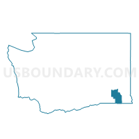
Outline

Summary
| Unique Area Identifier | 683989 |
| Name | Mustard Voting District |
| County | Columbia County |
| State | Washington |
| Area (square miles) | 0.28 |
| Land Area (square miles) | 0.28 |
| Water Area (square miles) | 0.00 |
| % of Land Area | 100.00 |
| % of Water Area | 0.00 |
| Latitude of the Internal Point | 46.31254550 |
| Longtitude of the Internal Point | -117.96886050 |
Maps


Graphs
Select a template below for downloading or customizing gragh for Mustard Voting District, Columbia County, Washington


Neighbors
Neighoring Voting District (by Name) Neighboring Voting District on the Map
- Columbia Voting District, Columbia County, WA
- Dayton Voting District, Columbia County, WA
- Patit Voting District, Columbia County, WA
- Ping Voting District, Columbia County, WA
- Rainwater Voting District, Columbia County, WA
- Star Voting District, Columbia County, WA